Arghakhanchi District
Arghākhā̃chī District
अर्घाखाँची जिल्ला | |
|---|---|
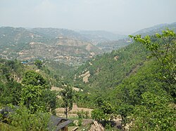
 Valley in Arghakhanchi district | |
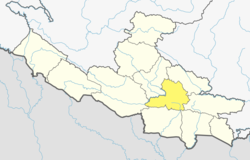
 Location of Arghakhanchi (dark yellow) in Lumbini Province | |
| Country | |
| Province | Lumbini Province |
| Admin HQ. | Sandhikharka |
| Government | |
| • Type | Coordination committee |
| • Body | DCC, Arghākhānchī |
| Area | |
| • Total | 1,199 km2 (463 sq mi) |
| • Rank | 077 |
| Population (2011)[1] | |
| • Total | 197,632 |
| • Density | 160/km2 (430/sq mi) |
| Time zone | UTC+05:45 (NPT) |
| Main Language(s) | Nepali |
| Website | daoarghakhanchi |
Arghakhanchi (Nepali: अर्घाखाँची जिल्ला [ʌɾɡakʰãt͡si] ) is one of the districts of Lumbini Province in Nepal. The district headquarter is Sandhikharka. The district covers an area of 1,193 km2 (461 sq mi) and has a population (2011) of 197,632.[1] Its neighboring districts are Palpa in the east, Gulmi in the north, Kapilvastu District in the south and Pyuthan in the west. The district also covers 4.18 km of road connecting Kapilvastu and Bhalubang, Lalmatiya, Dang with Rapti River as Mahendra Highway or Easy-West Highway.
History
[edit]The district consists of two pre-unification principalities Argha and Khanchi. Argha (Nepali:अर्घा) was the name given to ritual offerings made at the former principality's main Bhagwati Temple. Khanchi may come from the word Khajanchi (Nepali:खजाञ्चि) or tax collector since the center of the latter principality was known for its tax office. Both were two of the Chaubisi rajya (24 principalities) centred in the Gandaki Basin. In 1786 A.D. (1843 BS) during the unification of Nepal the two were annexed by Gorkha. Later the merger was renamed “Arghakhanchi” and added to Gulmi District. Arghakhanchi became a separate district in 1961 A.D. (2018 BS).[2]
Demographics
[edit]| Census year | Pop. | ±% p.a. | ||
|---|---|---|---|---|
| 1981 | 157,304 | — | ||
| 1991 | 180,884 | +1.41% | ||
| 2001 | 208,391 | +1.43% | ||
| 2011 | 197,632 | −0.53% | ||
| 2021 | 177,200 | −1.09% | ||
| ||||
| Source: Citypopulation[3] | ||||
In 2001, the population was 208,391.[4] In 1991, the population was 180,884.[4]
At the time of the 2011 Nepal census, Arghakhanchi District had a population of 197,632; 86,266 male and 111,366 female. The total number of households was 46,835 and the average household size 4.22 on the basis of usual place of residence. The sex ratio (number of males per 100 females) was 77.5 and population density was 166.[1]
As their first language, 97.5% spoke Nepali, 1.3% Magar, 0.5% Kumhali, 0.2% Newar, 0.2% Urdu and 0.1% Kham.[5]
Ethnicity/caste: 32.8% were Hill Brahmin, 18.2% Chhetri, 18.0% Magar, 11.3% Kami, 6.1% Sarki, 3.4% Kumal, 3.2% Damai/Dholi, 2.8% Newar, 0.9% Gharti/Bhujel, 0.9% Musalman, 0.6% Thakuri, 0.5% Sanyasi/Dasnami, 0.4% Gurung, 0.2% Terai Brahmin, 0.1% Badi, 0.1% Gaine, 0.1% Tharu and 0.1% others.[6]
Religion: 97.0% were Hindu, 1.9% Buddhist, 0.9% Muslim and 0.1% Christian.[7]
Literacy: 72.5% could read and write, 2.2% could only read and 25.3% could neither read nor write.[8]
The latest update of population of Arghakhanchi district according to 2021 Nepal census is noted as 177,086 with population density of 148.4/km2.
Geography and climate
[edit]Arghakhanchi lies between 27'45"N and 28'6"N latitude, and 80'45"E to 83'23"E longitude. It covers 1,193 km2. The altitude of the district varies from 305 to 2515 meter above the sea level. 68% of the district is in the mountainous Mahabharat Range and the rest is in the Siwalik Hills. Elevations range from 305 to 2575 m above sea level and about 40% of the total area is forested.[2]
The major rivers of the district are Bangi Khola, Bangsari Khola, Mathurabesi Khola, Banganga Khola, Durga Khola, Sita Khola, Khakabesi Khola, Rangsing Khola, Ratne Khola, Jhimruk Khola, Khankbesi Khola and Thada Khola. Thada lake and Sengleng lake are the major lakes of the district.
| Climate zone[9] | Elevation range | % of area |
|---|---|---|
| Lower Tropical | below 300 meters (1,000 ft) | 0.2% |
| Upper Tropical | 300 to 1,000 meters 1,000 to 3,300 ft. |
50.5% |
| Subtropical | 1,000 to 2,000 meters 3,300 to 6,600 ft. |
49.1% |
| Temperate | 2,000 to 3,000 meters 6,400 to 9,800 ft. |
0.2% |
Administration
[edit]The district consists of six municipalities, out of which three are urban municipalities[10]
- Sandhikharka Municipality
- Sitganga Municipality
- Bhumikasthan Municipality
- Chhatradev Rural Municipality
- Panini Rural Municipality
- Malarani Rural Municipality
Towns and villages
[edit]The major town in the district is Sandhikharka which is the headquarters of Arghakhanchi district. It is almost 300 km (190 mi) southwest of Nepal's capital of Kathmandu.
There are many small villages in the district, including Mareng, Bhagawati, Asurkot, Chhatradev Arghakhanchi, Chhatragunj Arghakhanchi Lamchi, Balkot, Bangi, Dharapani, Sandhikharka Dhikura, Dibharna, Khanchikot, Kimadada, Kura, Phudbang, Bangla, Adguri, Khana, Khanadaha, Pali, and Dhatiwang, Thada, Pharasawa Takura, Amarai, Pattharkot, and Jukena.
References
[edit]- ^ a b c "National Population and Housing Census 2011(National Report)" (PDF). Central Bureau of Statistics. Government of Nepal. November 3, 2012. Archived from the original (PDF) on May 25, 2013. Retrieved November 3, 2012.
- ^ a b "Districts". 28 June 2012. Archived from the original on June 18, 2010. Retrieved 18 August 2012.
- ^ "NEPAL: Administrative Division". www.citypopulation.de.
- ^ a b "Nepal Districts". statoids.com. Retrieved 18 August 2012.
- ^ NepalMap Language [1]
- ^ NepalMap Caste [2]
- ^ NepalMap Religion [3]
- ^ NepalMap Literacy [4]
- ^ The Map of Potential Vegetation of Nepal - a forestry/agroecological/biodiversity classification system (PDF), . Forest & Landscape Development and Environment Series 2-2005 and CFC-TIS Document Series No.110., 2005, ISBN 87-7903-210-9, retrieved Nov 22, 2013
- ^ "Local level body". Ministry of Federal Affairs and General Administration. Retrieved 1 October 2018.


